The resort village of Dombay is located in the Republic of Karachay-Cherkessia, near the borders of the Teberda State Reserve. Nature has collected a huge number of amazing places in these places: snow-capped mountain peaks, gorges with hundreds of waterfalls, transparent rivers and lakes fed by ancient glaciers. The highest peak is Dombay-Ulgen, and the largest and most famous glacier is Alibek.
Dombay is most widely known as a popular place for winter recreation. However, those wishing to see all the natural beauty should come here in the summer. Hiking along the Alibek, Amanaus, Gonchakhir and Dombay-Ulgen gorges, along narrow paths among alpine meadows will lead to unforgettable places. You cannot leave Dombai without seeing the Russian glade, the Baduk lakes and the Devil's Mill waterfall, without going through the route along the slopes of Semenov-Bashi.
The most interesting and beautiful places in Dombai
List, photo with names and descriptions of the best attractions
Dombay ski resort
The popular resort is located in a conservation area, in a large meadow where three mountain gorges converge. The tourist complex is an all-season one; in warm weather, hiking, mountaineering, horseback riding, paragliding and rafting are popular here. The ski season lasts from December to April, the total length of the slopes is 20 km, a large network of lifts of various types. The resort's hotels have everything for a comfortable stay, restaurants and cafes, saunas and swimming pools, clubs and bars.

Mount Mussa-Achitara
Climbing this mountain is considered a must on any visit to Dombay. In good weather, from its top you can admire Elbrus and the views of the Caucasian ridge. And if it's cloudy outside, a walk among the clouds awaits you. You can climb the mountain both on foot and by lifts. The guides have many fascinating stories about the surrounding peaks and gorges. The height of the mountain is 3,012 meters. At the top, even in summer, the snow does not melt; there is a cafe and the upper station of the cable car.

Dombai cable cars
A large network of lifts covers the slopes of the resort. The maximum lifting height is 3,168 meters. The first two stages of the old cable cars are single-chair lifts, from the third to the fifth stages - double-chair lifts. The fifth stage is backed up by Yugoslavka, stopping 20 meters below the upper station of the KKD. The new complex consists of three phases: the first is of the gondola type, the second and the third are of the chairlift. A pendulum road with 35-seat carriages lifts from the village to the top of Mussa-Achitara.

Alibek gorge
The route along the gorge is the most popular on Dombai, the total length is 20 km, to the Alibek waterfall - 13 km. At the very beginning of the path, there is a climbers' cemetery, then a waterfall, a glacier and Turye Lake. The path passes through beautiful places, it is not difficult to overcome it. Entrance through the checkpoint of the reserve with the presentation of a passport, the territory borders on Abkhazia. From the beginning you can get to the Alibek alpine camp by jeeps.

Alibek waterfall
One of the most powerful waterfalls in Dombai, formed by the fall of the Dzhalovchatka River from the rocky slopes. The rocks have a rounded shape, they are called "lamb's foreheads". The river originates from the glacier. It is located 2 km from the Alibek climbing camp and 5 km from the village. About 90 years ago there was no waterfall, there was a glacier in this place. The height of the water fall is 25 meters. From the top of the waterfall you can see the entire Alibek gorge.

Alibek glacier
The most accessible glacier of the Caucasus Mountains is located at the end of the Alibek Gorge, 8 km from the village. The path to the glacier is not included in the official tourist routes, as it goes through the border area. It gradually melts, retreating by 8 meters per year. As a result of melting, a waterfall and Turye Lake were formed. The view of the glacier with ice grottoes and caves is really impressive, its area is about 900 hectares.

Turye lake
The moraine lake, formed by the melting of the glacier, is filled with clear ice blue water and is surrounded by rocks. It got its name due to the fact that tours and chamois come down here to drink, they say that you can see them at dawn. It is located 8 km from the village, the path is not difficult, but at the end it is necessary to wade the mountain river, as the bridges were destroyed. There is an unofficial route through the glacier.

Baduk lakes
Three mountain lakes are located at an altitude of 2,000 meters, through which the Baduk River flows. To get here, you need to overcome about 4 km on foot through protected forests and a stone kurumnik. The first lake is the smallest; there is a path from it to the second. Here on the shore you can sit in the gazebo for a picnic. The third lake is the largest. The water in the lakes is clear, even in summer it does not heat above 5 0C. Having overcome 4 km higher along a more difficult path, you can reach another lake on the river.

Mount Belalakaya
The mountain peak is 3,681 meters high. The name translates as "mountain with variegated stripes", due to the white quartz ledges on the slopes. A little to the east of the main height is the second peak, Malaya Belalakaya. The mountain is often compared to the Alpine Matterhorn; it can be seen from anywhere in Dombai. Climbing routes with experienced instructors are organized for those wishing to conquer the summit.

Climbers cemetery
About 3 km from the village, at the beginning of the Alibek Gorge, there is a memorial cemetery. The climbers who conquered the peaks of Dombai are buried here, as well as monuments to those who did not return from the mountains were erected. Commemorative signs have dates from 1960 to 2003. Names and commemorative inscriptions can tell a lot about the history of these places. Stone slabs merge with the surrounding landscape, in summer crocuses and rhododendrons bloom here.

Amanaus gorge
The mountain river Amanaus flows along the bottom of the gorge, it is located south of the Dombai glade, towards the Abkhaz border. Here is the route to the Sofrudzhinsky waterfalls. The name translates as an evil mouth, the gorge is quite narrow, in some places the rocks converge up to one meter. It is called an open-air museum, and there are many natural minerals. Streams and rivulets flow down the rocks from all sides, forming small waterfalls, the largest waterfall in the gorge is the Devil's Mill.

Sofrudzhinsky waterfalls
Three large waterfalls are located in the valley of the Amanaus River. The first, the smallest, is 60 meters high. The second strikes with its power, falling from a height of 250 meters and forming a lot of splashes. The third waterfall is further down the valley, there is no path to it, and it is less visited by tourists. Water streams start from the Sofrudzhi glaciers. The long and difficult journey to these places is justified by the unforgettable views.

Canyon and waterfall "Devil's Mill"
The canyon and the waterfall of the same name are located in the Amanaus valley, an hour's walk from the center of the Dombay village. At the bottom of a narrow gorge, compressed by high rocks, a river foams. The waterfall lives up to its name, powerful streams are ground with great force, twisting into whirlpools. You can see it only by going upstairs, the site is not fenced in anything and is quite dangerous. However, the breathtaking views are well worth it.

Summit Tooth Sufruju
This peak is clearly visible from the village, as well as from the slopes of Mussa-Achitara. Mount Surfuju is divided by a canyon into two peaks, the southern one is called the Tooth Surfuju, or tiger's fang. It has a height of 3,600 meters. The Jessarsky pass connects it and the top of Zadnyaya Belalakai with huge glaciers. From the top one can see the lamb's foreheads, polished by the Amnauz glacier, as well as the Surfudzhin icefall, sliding ice blocks.

Dombay-Ulgen gorge
The gorge is considered the sunniest place in Dombai, along it there is an eco-route to the Russian glade and the Chuchkhur waterfalls. It is considered one of the easiest to learn, but at the same time the most beautiful.The surrounding area offers views of the picturesque surroundings. The Musa-Achitara ridge rises on the left, cable cars are stretched. On the right is the Main Caucasian Ridge, and the Dzhuguturlyuhat covered with glaciers.

Mount Dombay-Ulgen
The highest mountain in the Western Caucasus, its height is 4,046 meters. It is located east of the village of Dombay, on the Abkhaz border, has three peaks, approximately equal in level. The name translates as “the place where the bison died”, these animals used to be found in these places. The peaks are covered with eternal snows. To the north of the main height there is a depression, the Dombai saddle, from which there are climbing routes. Their complexity is high, from 3 to 5 points.

Mountain and glacier Dzhuguturluchat
One of the massifs of the Main Caucasian ridge has a height of 3,921 meters. The name means "pasture of tours", these animals from the Red Data Book are still found here. A vast glacier, indented by cracks, gives rise to a powerful waterfall that flows down to the Russian glade. The best views of the mountain are from the Mussa-Achitara observation deck.

Dzhuguturluchat waterfall
A water stream 20 meters high flows from the glacier of the same name and flows into the Dombai-Ulgen river. It is located at an altitude of 2,500 - 2,800 meters and is clearly visible from many places. The attraction does not require overcoming difficult routes for inspection, views of the waterfall open from the chairs of the cable car and the observation deck of Mussa-Achitara, as well as from the cafe on the slopes.

Russian glade
Real subalpine meadows are located at the foot of Dzhuguturluchata. The glade, surrounded by the panorama of the Dombai Mountains, is named after Russian geologists who were the first to camp here in the 19th century. It is home to many animals and birds; in periods free from tourists, roe deer and tours descend from the mountains. In spring and summer, the clean mountain air is complemented by the aromas of flowering herbs. The highest peaks, the Dombai-Ulgen river, are clearly visible from here. Through the clearing lies the path to the Chuchkhur waterfalls.

Ine Peak
The pointed snow-white peak is considered one of the iconic places of Dombai and its main decoration; it rises next to the Dzhuguturluchat massif. The height is 3,455 meters, the slopes are almost completely bare steep cliffs, with a non-melting snow cap. The best views are in sunny weather, from the cable car and the slopes of Mussa-Achitara. Climbing the peak is very dangerous, but the number of those who want to conquer it does not decrease. The name translates as "Needle".

Chuchkhur waterfalls
The Chuchkhur River, flowing down the rocky slopes to the Russian glade, joins the Dombai-Ulgen River. On its way, it forms two beautiful cascades of waterfalls surrounded by dense forest. The path to the first cascade is not difficult, to the second one will have to overcome a difficult route: 300 meters up the mountain path. Above, there are beautiful views of the Dombai-Ulgen gorge and the entrance to the Chuchkhur gorge.

Ptysh waterfalls
A complex of waterfalls of various sizes flows down from the rocky clones of the Ptysh gorge, their second name is "Maiden's Spit". The river North Ptysh originates from them. Since the waterfalls are formed by the melting of the glacier, their number varies from seven powerful streams in the spring to three small streams in the fall. If you wish, you can climb to their sources, to the very foot of the glacier.

Ptysh glacier
The only glacier of the first category on Dombai, its area reaches 2 km2... The view of the glacier is truly mesmerizing: going down from the saddle of the Ptyshsky pass, the ice stratum literally cuts into the green of the alpine meadow. The lower tongue of the glacier is at an elevation of 2,000 meters. Those who want to climb it should be careful: the surface is cut with cracks, it is easy to slip on it. You can get here by going through the Russian glade.

Gonachkhir river gorge
The gorge is located between the villages of Dombay and Teberda, near the confluence of the Gonchakhir and Amanauz rivers. The name means bottleneck. The entrance to the gorge is indeed framed by steep cliffs that are closely compressed, further the slopes part, forming a picturesque valley. There is a border area here, only 15 km out of a total length of 30 km are open for tourists. The route can be traveled by car.

Lake Tumanly-Kel
The large mountain lake is considered the pearl of the Gonchakhir gorge. It is located at an altitude of 1,850 meters, the name translates as "foggy", fogs are not uncommon here. In sunny weather, the shores offer stunning views of the surrounding mountains. The water is cold, but on hot days it warms up to 20 0C. Earlier, trout was bred here, it is found in the lake now, however, fishing is prohibited.

Valley of the Ullu-Muruju River
The river belongs to the cleanest water bodies in Europe, its clear turquoise water is considered curative. It originates from glaciers, the bottom is rocky, in places lined with huge boulders. It flows through a very picturesque valley, which overlooks the Muruja igloo. Near Teberda and Dombai, the banks are surrounded by a pine forest. The route through the valley is not easy, there are mountain lakes in the upper reaches.

Muruja lakes
A group of lakes on the Ullu-Muruju River, at an altitude of 3,000 meters in a protected area. Only trained travelers will be able to reach them; it will take two days of walking. Three lakes: Peacock Eye, Black and Blue, are the most famous, even upstream there are an uncountable number of small bodies of water. The water in Blue really has a fabulous turquoise hue; it is the largest on Dombai (500 meters long, 52 meters deep). Peacock's eye is the warmest lake.

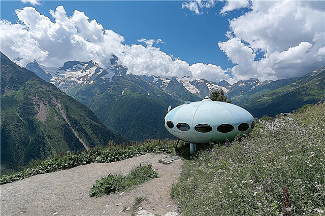
Hotel "Plate"
Among the numerous guest complexes in Dombai, this object stands out for its unusual appearance and history. The hotel was built in 1979 on the slope of Mussa-Achitara, at an altitude of 2,250 meters. It was presented to Dombai by the President of Finland, who conquered local peaks. The structure looks like a UFO, lost in the mountains, and is designed for 6 people. It still receives guests, the interior also corresponds to the space theme.

Semenov-Bashi ridge
The Dombay village stands at the very foot of this ridge. It was named in honor of the traveler Semyonov Tyan-Shanskiy, the height is 3,602 meters. The summit is always covered with a snow cap. At an altitude of 2,750 meters, there is the Crystal Lake with blue transparent water, through which even the stones at the bottom are visible. The Crystal Pass at an altitude of 3,100 meters offers beautiful panoramas of the surrounding peaks and gorges. Routes of varying difficulty pass along the ridge.

Klukhorskoe lake
A large glacial lake in the vicinity of the Klukhorsky pass is located near the Abkhaz border. Height above sea level is 2,700 meters, the lake is surrounded by rocks. You can get here by an asphalt road from the Teberda River. The lake is 400 meters wide, 500 meters long, and 11 to 35 meters deep. The water is turquoise with a milky tint, very cold. Ice melts only in summer. The noisy Northern Klukhor River flows out of the lake.